Aerial archaeology J. Dassie. Climatology.
Climatology
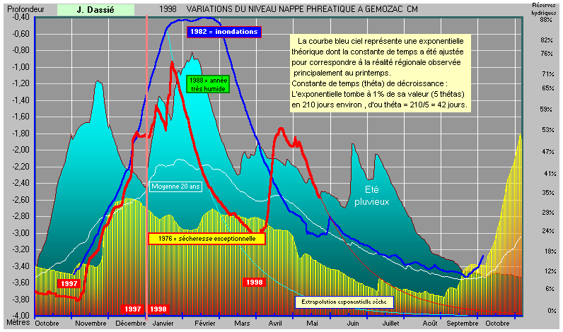
: the hydrous assessment.Previous page showed how much the visibility of revealing signs was tributary of moisture present in the ground. Since 1977 I formulated the " Bilan Hydrique Intégré" (Integrated Hydrous Assessment ), index characteristic of water reserves (Bib.). This model, of regional application, allows, by an easy extrapolation, a certain forecast of the periods most favorable to the prospections. But there is a method even simpler: the recording of the level of ground water (measuring the depth of water in a well). It is not the intrinsic value obtained, very different according to situation of the well, but its variations, which, translated into curves with a computer, allow a good examination and an immediate visual extrapolation. The example hereafter constitutes a good illustration of it.
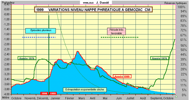
Variations of level of ground water in Gémozac CM, in 1997-1998.
(We begin the hydrous year at November 1)
Comments:
The great annual increase was done between the beginning of November and then beginning of the third decade of January. Red curve. No index is visible in water-logged soils with water. From the end of January to the end of March, a mode anticyclonic maintains a time dry and sunny. Absence of rain, diurnal temperatures high: the level of the ground water goes down again while following a perfectly exponential decrease. On the end of March the graminaceous start to suffer from dryness and revealing indices appear. A catastrophic increase in April comes to compromise everything, and the theoretical exponential decay (in blue) shows that it would be necessary - without new rains to wait until mid-June to find good conditions of visibility for archaeological indices. A question is often put: " Which are the periods most favorable for air prospections? " That depends of course of the years, but one can summarize the averages observation in the form of a diagram:
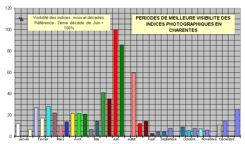
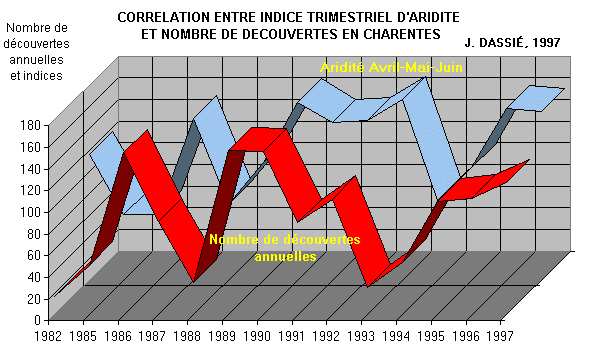
You can notice the increase of discoveries due to the tempests of February, but especially the great period of differential maturation of cereals, with his paroxysm in the third decade of June. These observations were carried out over a thirty years period surroundings. They are valid for south Poitou-Charentes. But what happen according to the years?
There, of appeared differences, well highlighted by the following photograph:
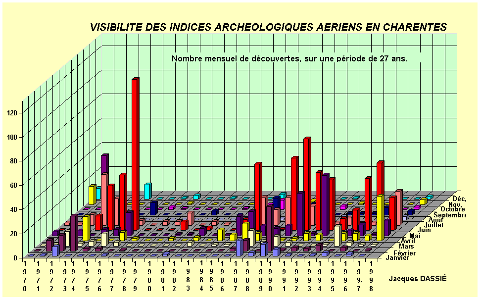
The image is self-explicit, except for the period 1977-1984 when the fall of the discoveries was due to the absence of the prospector, very often on professional journeys abroad. The extraordinary dryness of June 1976 is particularly obvious here.
Other curves can be of interest: the period of accumulation and loss of the hydrous reserves

You can see clearly that the great annual increase is not carried out on fixed date, but can be spread out according to the years, over a 4 to 5 months period.
It is the same for the periods of dryness, with however a spectacular regrouping at the end of the summer. At the end of September, it always makes very fine weather in Poitou-Charentes!
This curve is very interesting because it constitutes the obvious demonstration of the perfect existing correlation between dryness and appearance of archaeological indices. When dryness is raised and that vegetation suffers, it is there that it translates best this suffering by differences of size, colouring or yellowing. In addition the years are followed and do not resemble absolutely.
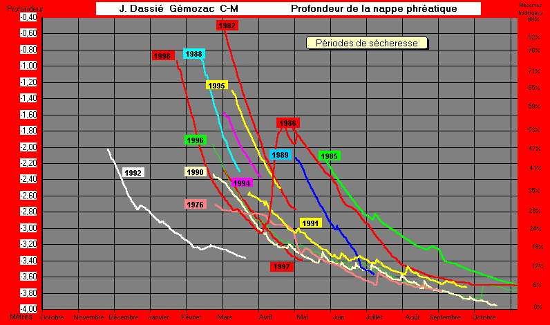
. It is interesting to show a comparative group of curves presenting the extreme characteristic years:
1982: Curve in dark blue. The level of the ground water goes up until the moment where it cannot go up high any more without being spread out through the countryside! It is a period of large floods.
1988: Curve in light blue. A "rotted " spring perfect illustration and a summer. A feeling of " rain all the time," even if it is inaccurate. Bad year for the prospections!
1976: Yellow curve. Year of the century for the air prospector, the farmer and the taxpayer... But not exactly for same reasons!
1998: Red curve: A promising beginning of year, with very good results in March. The increase in April came to compromise this good departure that the starter of dryness in May seems to want to correct. But results are not good: there are too many reserves of water and vegetation does not suffer absolutely. Hence cereals fields present reliefs and colors perfectly homogeneous.
|
|
|
|