DATA PROCESSING
BANQUE ARCHEOLOGIQUE POITOU-CHARENTES (BAPC)
Program " ARCHEO ": MANAGEMENT OF THE BAPC
The database and "ARCHEO " (software) were initially conceived in 1985 to receive the results of Jacques DASSIÉ's air archaeological prospections. These results had to be presented in a form equivalent to that of the handwritten card of declaration of archaeological discovery prescribed by the Sous-Direction de l'Archéologie.
Thereafter, it appeared desirable to be able to accomodate work of other prospectors (air or ground). Lastly, following a request for various Companies, ARCHEO became a genuine tool of archaeological inventory, multifile, able to manage all types of sites. Program ARCHEO and its archaeological files ARCHEO_n are actually used by the Service Régional de l'Archéologie POITOU-CHARENTES, (SRA), as well as within various Archaeological Companies in Charente Maritime, and by various independant prospectors .
Moreover, archaeological file cards accomodate all complementary texts (Bibliographies, etc), maps and color photographs. These capacities, single among archaeological data banks, are gathered under the name of
"BANQUE ARCHEOLOGIQUE POITOU-CHARENTES ".
Program " ARCHEO "
Program " ARCHEO " is a software conceived especially to manage the archaeological database "ARCHEO" support of the BAPC. Its vocation of editor and manager of archaeological cards enables him to treat the card of declaration SRA, while supplementing it by new information: geology, typology, mailing list, number of edition etc. In addition to normal functions of making up, conservation and restitution of the cards, other more complex functions ensure sorting and multiple selections, thus constituting a powerful tool for analysis and search sets of themes. Comfort and ease of use are much larger with this especially dedicated program.
Technical means
The current version of program " ARCHEO ", with a file of 3000 cards, occupies approximately 150 Mo on hard disk. This occupation is directly a result of the iconography presented. Each image color, full screen (640x480 pixels), 256 colors, requires in compressed version, 50 to 70 KB per image. The station PC compatible will be equipped with a graphics board and a SVGA screen. To facilitate the access to pictures to stations with insufficient space on their hard disk, the BAPC also functions (only in advisory mode) on CD-ROM.
FUNCTIONS OF PROGRAM " ARCHEO "
Responsibilities
Each organization or person in charge of file can only reach actively (writing, modifications or cancellations of cards) its own file, presented like " active " in the title of the personalized program, this in order to guarantee the full Authors's responsibility.
"Passive " functions (reading, selection, multicriterion selections, search for 'commune' (parish)) are carried out on the totality of the files present, in a completely transparent way for the user. We wish for this program the simplest possible and completely conversational use, i.e. the computer dialogues with his user who answers by introducing the data requested. Many tables propose possible answers and provide the necessary thesaurus.
Writing
A safety system authorize writing on the only file of the holder. From the very start of writing, the program announces the possible empty cards (thus available). The cards can be written in any numerical order. Without particular precise details, the program allocates numbers to be followed (strongly recommended method). At the end of writing, permanent filing on hard disk is automatic. A device checks co-ordinates of the new card and alarm the writer on the existence of former cards, concerning the sites present on a surface of 1 Km² centered on the position. This one can thus carry out all the checks necessary in order to avoid doubles or triple declarations (shortcoming of many data banks, even official. It can however exist particular cases and the final decision will always belong to the writer responsible for the card.
Selections
The call of " Selection " will open the gates of the following headings:
Year or year and month of discovery
Author of the first discovery
Department, district, canton or commune
Writer of the card
Author of photography
Supposed or checked archaeological era
Geographical map 1/25000e (sites being reproduced on the map by 1/2 sheet).
Altitude of the site or sections of higher or lower altitudes
Year and / or month, day of photography
Letters, numbers or words to be sought in all the headings:
Belonging to a geographical surface defined by 2 points Lambert.
The power of these functions is really extraordinary. One will be able to seek:
All "Maines" or them "Chez", for a toponymic study of
All ditches, or enclosures, or enclosures, or well qualifiers: passage, triple, multiple etc
All sites of altitude lower than X meters, for a study on marshes
All controls on ground carried out by Mr. X...
All revealing indices: moisture on, naked ground, maturation cereals etc
All sites of a surface defined by its co-ordinates Lambert
All sites characteristic of Peu Richardien continental etc
All sites presenting of the " crab grips ", etc
All sites of a same generic family: " castles ", " mounds ", " ways ", etc
This enumeration of the possibilities of program " ARCHEO " is by no means exhaustive so much the combinative possibilities of the functions are considerable. It will be noted that combinative of functions is considerable. One will note that these performances are possible from the startup, practically without training, by a user not-data processing specialist.
CONCLUSIONS
The operating mode of the Archaeological Bank Poitou-Charentes is simple and logical.
Designer of the B.A.P-C. and the family of programs " ARCHEO ", J. Dassié reserves the responsibility for management and overall technical coordination. Each creator of file using program " ARCHEO " takes part de facto in the Archaeological Bank Poitou-Charentes. The archaeologists, members of the B.A.P-C., reach the knowledge of the totality of the regional sites taken into account, widening their geographical framework and their vision of the archaeological problems, thus opening the possibility of many new studies.
NOTA: With regard to duplication or transfer of photographs, the exploitation of the rights always remains under their author' s exclusive responsibility, protected by copyright.
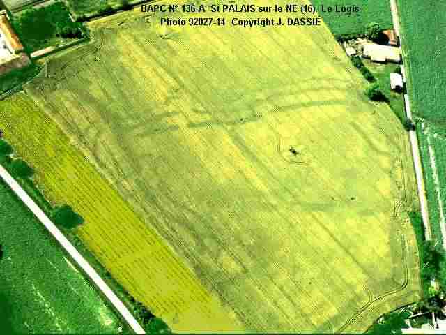
Example : a BAPC file card.
Fiche 136-A Déclaration J. DASSIÉ au Service
Régional de l'Archéologie POITOU-CHARENTES
AP
Découverte :
Jacques DASSIÉ Prospections aériennes du 02-07-1978
Catégorie : D
CHARENTE
SAINT-PALAIS-SUR-LE-NÉ "Le Logis" Code INSEE=
16206342
Carte IGN 1/25000e :
Baignes-Ste-Radegonde No 1633 Feuille Ouest Géologie :
Campanien
Coordonnées Lambert
3 Ax = 396.800 Ay =
3362.800 Altitude = 35m
Bx = 397.100 By = 3363.100
Surface curvimétrique = 9 Ha
Epoque
présumée : Néolithique récent
Peu-Richardien continental Indices : Maturation des
céréales
Structures : Enceintes
à fossés multiples et à passages Camp de
versant. Enceintes multiples mitoyennes.
Fossés triples. Pinces de crabe multiples.
Contrôle sol :
Claude Burnez 1986. Camp néolithique confirmé Peu
Richardien continental.
Photographies :
|
|
|
|
|
|
|
|
|
|
|
|
|
|
|
|
|
|
|
|
|
|
|
|
COPYRIGHT Reproduction / publication photos interdites sans autorisation Jacques DASSIÉ
Edition 3 créée le 24-03-87 Date dernière mise à jour : 24-03-1987
Fiche 136-A Diffusion lot 06 : SRA_Poitou-Charentes + photos, BURNEZ + photos, B.A.P-C.
2) REDRESSEMENT DE PERSPECTIVE
Dès que l'on souhaite établir le plan d'un site, on se heurte à la difficulté de faire correspondre l'image photographique et la carte à grande échelle ou le cadastre, afin de reporter aisément les traces observées sur un quadrillage Lambert.
La méthode la plus simple consiste à utiliser un logiciel de dessin vectoriel (genre CorelDraw, même dans ses versions les plus anciennes). Procéder de la façon suivante :
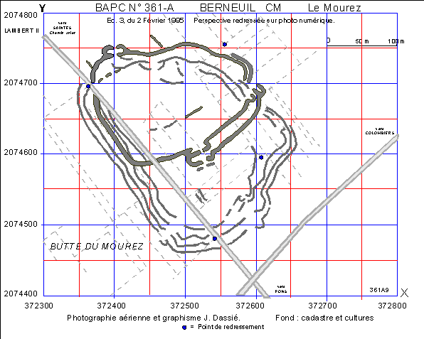
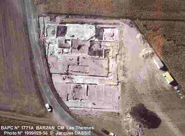
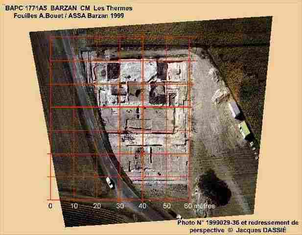
It also possible to work directly on photography, which gives the following results :
|
|
|
|